Establishing a nonprofit in Ohio 1. Name Your Organization- The first step in creating a nonprofit is to choose a name. In the state of Ohio, the only requirement for naming a nonprofit is that it must be different from all others recorded by the Secretary of State. 2. Name Incorporators and Directors- This is where the leadership team is formed. In this case, the leadership will be the board of directors and officers. The state of Ohio requires that you have a minimum of three directors. The directors do not have to reside in the state or be members of the organization unless stated otherwise in the bylaws. 3. Appoint a Registered Agent- Ohio requires all nonprofit organizations to have a registered agent. The Registered agent can be an individual or company and be responsible for receiving all legal notifications for the nonprofit. This person or business is required to have ...
Posts
Mole Salamander Family
- Get link
- X
- Other Apps
Family: Ambystomatidae This Family of salamanders is found all over the world in many different forms. Some of the more well-known species in this family include the spotted salamander, tiger salamander, marbled salamander, and the very well-known axolotl. this family of salamanders has chunky bodies with broad, flat heads and short legs. they have 10 costal grooves. most species has a larval stage that extends 3-4 months.
App reviews
- Get link
- X
- Other Apps

Review of Naturalist Apps: HerpMapper: This is an app that I have been using for years now! It is designed for citizen scientists to be able to catalog and inventory species of reptiles and amphibians in their area. The way the app works is by allowing you to take a picture of a reptile or amphibian, the app then guides you and asks for basic information such as location, time, and date. after that is completed you then have the option to also upload a call from the animal if there is one. this allows for animal calls to be uploaded into the database as well. Once the picture or call has been uploaded, the user is then asked to select the species. the menu for selecting this can be challenging and intimidating if the person is not very knowledgable on species. it starts by asking you to select the family of the species then allows you to look at the genus and finally species. After the species has been selected the user is asked to review all of the information before s...
Web Soil Survey
- Get link
- X
- Other Apps

Web Soil Survey: Wastewater and irrigation discharge into the Olentangy River Review: I am very much a beginner in using the tool, but it was interesting to see how it worked. it is very similar to how GIS works, so getting the hang of it was pretty easy. I really enjoyed being able to see the tools that were provided to see different layers on the map. I chose to look at irrigation discharge and food and manure discharge to see how much, if any goes into the Olentangy River that sits along the park. Since a lot of my interest focuses on reducing nutrient pollution in water this is a really good tool that will be useful to look further into that!
- Get link
- X
- Other Apps
Weather and Climate Links: Climate Change in Ohio What Climate Change means for Ohio Climate Records Weather History I chose simple climate links for my study. I decided the most important data a resources would be on how exactly the climate in Ohio is and how it is changing. I also added weather and climate history to see how much it has changed over time.
GIS Map
- Get link
- X
- Other Apps

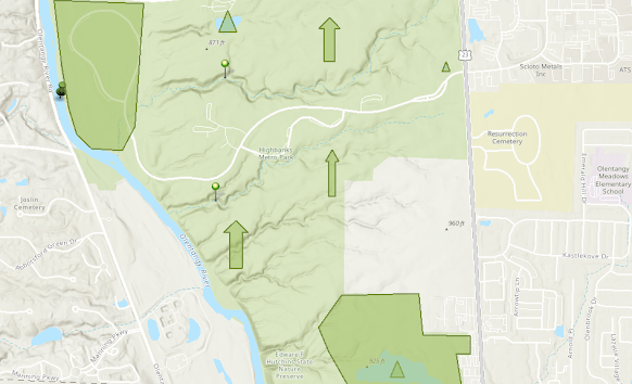
Highbanks Metro Park Above is a GIS map of Highbanks Metro Park in Columbus, Ohio. The park features many unique landscapes and habitat areas. the large shaded area on the top represents the prairie grass habitat and the lower shaded area represents the wetlands found in the park. The vertical arrow represents forested areas of the park. Most of the park is forested. The triangles represent ponds, the two pushpins in the middle represent tributaries and the larger pushpin represents the Olentangy river. Overall it was fairly simple to use the only mapping software. I have some familiarity with ArcGIS as I have taken a class for it in undergrad, however, the online version is a little different. I enjoyed looking through the various layers and tools that are available with the software.
Biodiversity
- Get link
- X
- Other Apps
Biodiversity What is it? To me, biodiversity is how many different species of plants, animals, fungi, and all other living organisms a given region has. It is also how rich and diverse an area is in different species. It can also be how the different species interact with one another and how they make up a certain ecosystem and how they contribute to the biosphere. Importance: Biodiversity is extremely important on all levels, not just locally. However, it is still important to all local ecosystems because each species plays a critical role and fills a niche in their respective ecosystems. without some species of predators, there can be an overpopulation problem of prey which can cause harm to landscapes and wipe out food supplies for other species. Biodiversity is also important at the global level because different species such as birds and insects migrate and do not stay in now place all year. these species play important roles in multiple ecosystems and help ...